Ireland · County Clare
The Burren, Ireland: what it is, where it is, and how to see it
A limestone upland in north-west County Clare, with rare flowers, thousands of years of stone monuments, and a small national park. It looks bare from the road. It isn't.
- Where
- North-west County Clare, reaching into south County Galway, on the west coast of Ireland
- Size
- About 530 km² (estimates run 250–560 km² depending on where you draw the edge)
- Rock
- Visean limestone, about 325 million years old
- Best for flowers
- Late May for gentians and mountain avens; June for orchids and bloody cranesbill
- Protected areas
- Burren National Park (about 1,500 ha, opened 1991, free) and the Burren and Cliffs of Moher UNESCO Global Geopark
- Long-distance trail
- The Burren Way, about 114 km from Lahinch to Corofin
- Nearest airport
- Shannon, about an hour and a quarter by road to Gregans Castle, near Ballyvaughan
The short answer
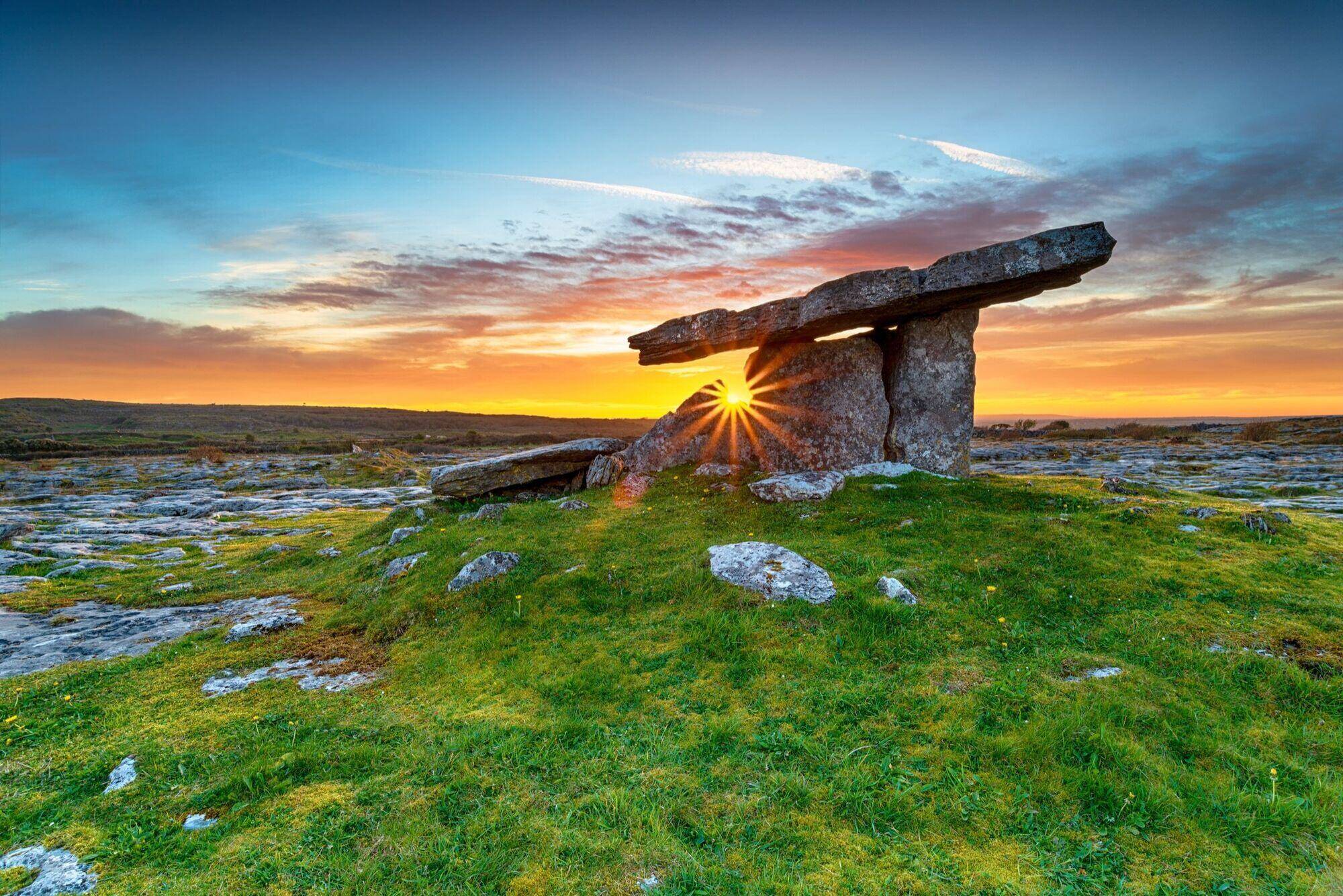
The Burren is a limestone landscape of about 530 square kilometers in north-west County Clare, Ireland, running down to Galway Bay and the Atlantic. The rock formed in a tropical sea about 325 million years ago, and the area is known for bare limestone pavement, Arctic-alpine and Mediterranean flowers growing side by side, and about 70 megalithic tombs, including Poulnabrone dolmen.
The Burren is the bare grey upland in the north-west corner of County Clare, on Ireland’s Atlantic coast. From the road it can look like a quarry with fields around it. Get out of the car and it holds more than 70 percent of Ireland’s flowering plant species and hundreds of prehistoric monuments. Below: what the Burren in Ireland is, where it is, how it formed, what’s in flower in June, the tombs and forts worth your time, the stories people tell about it, and the practical side: driving, trails, the national park and where to stay.
What is the Burren?
The Burren is a karst landscape: a region where limestone sits at or near the surface and water has dissolved it into cracks, caves and underground rivers. It covers about 530 square kilometers, though Wikipedia’s Burren article notes that estimates range from 250 to 560 km² depending on where you draw the boundary.
The best-known description of it is older than any guidebook. In 1651–52 the Cromwellian officer Edmund Ludlow wrote that it “is a country where there is not enough water to drown a man, wood enough to hang one, nor earth enough to bury him.” (Not a man who was enjoying his posting.)
It isn’t empty. Farmers have grazed cattle here for thousands of years, and the region holds about 70 megalithic tombs, more than 300 fulachtaí fia (ancient burnt-stone mounds) and almost 500 stone ring forts, according to the same source.
What does “Burren” mean?
The name comes from the Irish Boireann (Wikipedia spells it Boirinn), usually translated as “rocky district.” It’s not poetry. It’s a description, and an accurate one.
Where is the Burren?
The Burren is on the west coast of Ireland, in north-west County Clare, with a small part reaching into south County Galway. Galway Bay forms its northern edge and the Atlantic its western edge. The villages around it:
- Ballyvaughan on Galway Bay, in the north. See our Ballyvaughan guide.
- Doolin and Lisdoonvarna to the south-west, toward the Cliffs of Moher. See our Doolin guide.
- Kilfenora to the south, home of the Burren Centre and a set of high crosses.
- Corofin to the south-east, where Burren National Park has its information point.
The Cliffs of Moher sit just beyond the Burren’s south-west corner and are part of the same UNESCO Global Geopark.
How far is the Burren from Galway and Doolin?
- From Galway city: under an hour’s drive to Ballyvaughan, around the bay through Kinvara. Bus Éireann route 350 does the same run.
- From Doolin: you’re already on the Burren’s south-west edge. Ballyvaughan, on the far side, is roughly 30 km away by the coast road through Fanore (the R477 alone is 28.7 km).
- From Shannon Airport: about an hour and a quarter by road.
The Burren map: the main places at a glance
A bookmarkable list of the main stops, grouped by area. Drive times vary with the narrow roads, so allow extra time.
| Place | What it is | Area |
|---|---|---|
| Poulnabrone dolmen | Neolithic portal tomb, burials about 3800–3200 BC | Central Burren, on the R480 |
| Caherconnell | Stone fort, dating back to the 10th century, with sheepdog demonstrations | Central Burren, near Poulnabrone |
| Aillwee Cave | Show cave with brown bear remains and a Birds of Prey Centre | Near Ballyvaughan, on the R480 |
| Corcomroe Abbey | Ruined Cistercian abbey, founded about 1180–1210 | North-east, near Bellharbour |
| Leamaneh Castle | O’Brien castle ruin, seen from the road | South-east, where the R476 meets the R480 |
| Mullaghmore | Limestone hill in Burren National Park | South-east, near Corofin |
| Kilfenora | The Burren Centre and high crosses | South |
| Black Head and Fanore | Coast road, lighthouse, sandy beach | North-west |
| Doolin | Village, ferry pier and traditional music | South-west |
How the Burren was formed: the geology
The limestone under the Burren is Visean limestone, laid down in a tropical sea about 325 million years ago. Yes, a tropical sea. This bit of Ireland was a long way south of where it is now.
Much later, ice sheets scraped the surface clean. When the glaciers melted, roughly 10,000 years ago, they left the rock bare and dropped boulders behind them. These glacial erratics sit on the pavement wherever the ice left them.
Since then, rainwater has been dissolving the limestone along its cracks. That gives you the two words you’ll hear on any Burren walk:
- Clints: the flat slabs of limestone pavement.
- Grikes: the deep cracks between them. Some are deep enough to hide a six-foot person, so watch your feet.
Water doesn’t stay on the surface. It drains through the rock into more than 50 km of mapped caves. Aillwee Cave is the one most visitors see. In low ground, seasonal lakes called turloughs fill in winter and drain away in summer.
Burren flowers: what blooms in June
The flowers are the reason a lot of people come. More than 70 percent of Ireland’s flowering plant species grow here, including plants you’d normally expect hundreds of miles apart. As the Irish Examiner’s Anja Murray put it, “Nowhere else do Arctic and Alpine species grow alongside flowering plants normally only found in the Mediterranean.”
Why are the Burren’s plants unique?
It’s a mix of history and local conditions, as Ask About Ireland explains it:
- The Arctic-alpine plants are leftovers. They moved in as the glaciers retreated, and when the climate warmed, they stayed.
- The Mediterranean plants get help from the Atlantic. The Gulf Stream gives the west coast warm, moist air.
- The rock is a storage heater. Limestone soaks up warmth in summer and keeps winters mild enough for plants such as the dense-flowered orchid.
- The light is strong. Sea and pale limestone reflect a lot of light, which the Arctic-alpine plants need.
- The farming keeps it open (see winterage, below).
Many Burren plants also flower early, setting seed before the dry part of summer.
Timing matters. Here’s what you’re likely to see by month:
| Month | What is usually in flower |
|---|---|
| Spring | Early purple orchid and dense-flowered orchid, the first orchids of the year |
| May | Spring gentian (intense blue) and mountain avens (white and yellow) |
| Late May | Often the best overlap of gentians and mountain avens |
| Early June | Mountain avens, late spring gentians, heath spotted orchid, early purple orchid |
| June–July | Bloody cranesbill (bright pink), more orchids, summer wildflower meadows |
Sources differ by a few weeks on some of these: one Irish wildflower guide gives July–August for bloody cranesbill, while others say June–July. A late or early spring shifts everything.
Burren National Park says it holds 23 of Ireland’s 27 orchid species, including the fly, bee and butterfly orchids and four kinds of helleborine. Sources disagree slightly on exact counts, but every source agrees the Burren holds most of Ireland’s orchids. A guide who walked the Burren in early June listed mountain avens, spring gentian, heath spotted orchid and early purple orchid in flower, which shows how much overlap a late spring can give.
Butterflies follow the flowers. The marsh fritillary, Ireland’s only legally protected butterfly species, and the pearl-bordered fritillary both live here.
Please don’t pick or dig anything. Many of these plants are protected, and the patches are small.
Winterage: why the farming matters
The Burren is farmed, and the farming keeps the flowers. Under winterage, farmers move cattle up onto the limestone uplands at the end of summer and keep them there through the winter. The Burrenbeo Trust explains that the free-draining rock gives them a dry place to lie, and the cattle eat the rank grasses while most plants are dormant. That grazing keeps the ground open for wildflowers in spring and summer. The Burrenbeo Trust runs Burren in Bloom, a month of guided flower, butterfly and habitat walks, every May.
Archaeology: tombs, forts and churches
The Burren holds a great many prehistoric and medieval monuments. The main types:
- Portal tombs and wedge tombs. Of the roughly 70 megalithic tombs in the Burren, about 90 percent are wedge tombs. The most famous, though, is a portal tomb: Poulnabrone, where the remains of 33 people dated to 3800–3200 BC were excavated, according to Heritage Ireland.
- Stone forts (cashels). Almost 500 have been identified. Caherconnell, near Poulnabrone, dates back to the 10th century and is open daily with sheepdog demonstrations. Cahercommaun is another of the best known.
- Fulachtaí fia. More than 300 of these ancient burnt-stone mounds survive.
- Medieval churches and abbeys. Corcomroe Abbey, near Bellharbour, is a Cistercian abbey founded between about 1180 and 1210. It holds the tomb and stone effigy of Conor na Siudane Ua Briain, King of Thomond, killed in 1268. W. B. Yeats set his play The Dreaming of the Bones there. Kilfenora has high crosses and the Burren Centre.
- Castles. Leamaneh Castle, an O’Brien castle now in ruins, stands at a crossroads in the south-east Burren. It started as a tower house around 1480–90, and a mansion was added around 1648; it was the home of Máire Rua O’Brien, who, the story goes, married three times to keep her lands. Gregans Castle, near Ballyvaughan, was the seat of the O’Loughlin family, called the “Princes of Burren.”
The Burrenbeo Trust also runs the Burren Archaeology Festival in Ballyvaughan. In 2026 it was held on 20 and 21 June, with talks by archaeologists including Dr Ann Lynch, who led the Poulnabrone excavation.
Myths and stories of the Burren
Stories have stuck to a lot of places here. A few worth knowing before you go:
- The Tuatha Dé Danann and the Sídhe. In Irish myth, the Tuatha Dé Danann, the old gods of Ireland, went into the hills and mounds after their defeat and became the Sídhe, the fairy folk. Ring forts across Ireland are still called fairy forts. Our guides to the Tuatha Dé Danann and fairies in Irish folklore go into this properly.
- Diarmuid and Gráinne’s beds. In the medieval story The Pursuit of Diarmuid and Gráinne, Gráinne is promised to the aging Fionn mac Cumhaill but runs away with his young warrior Diarmuid, and Fionn chases them across Ireland. Many flat-roofed Neolithic monuments in Ireland, including dolmens and wedge tombs, carry the local name “Diarmuid and Gráinne’s Bed” (Leaba Dhiarmada agus Ghráinne), as places the couple slept on the run. We couldn’t find a record of Poulnabrone itself being called that, so we don’t claim it is. On the Clare coast, the Cliffs of Moher legend of Mal the hag names a “Diarmuid and Grainne’s Rock” near the mouth of the Shannon.
- The hag and the mermaid. The Cliffs of Moher, just south of the Burren, have their own legends: Mal the sea-witch at Hag’s Head, and the mermaid of Moher whose cloak was stolen by a fisherman. They’re in our Cliffs of Moher guide, and the mermaid story sits in the same family as the selkie myths.
- Lady Gregory’s fairy beliefs. Lady Gregory collected fairy beliefs from farmers around Gort and north Clare and published them in Visions and Beliefs in the West of Ireland (1920).
If you read fae romance, a lot of it comes from these stories. Our guide to fae romance books traces some of those roots.
Films and TV shot in the Burren
The Burren’s most famous screen role is comic. In the sitcom Father Ted, the exterior of the Craggy Island Parochial House is Glanquin farmhouse in Kilnaboy parish, in the south-east Burren. It’s a private family home: there’s no parking at the house and the lane is narrow, so look from the gate or the road. (Please don’t knock and ask for Mrs Doyle.) In the episode “The Mainland,” the “Very Dark Caves” are Aillwee Cave.
Just outside the Burren, the Cliffs of Moher played the Cliffs of Insanity in The Princess Bride and appear in Harry Potter and the Half-Blood Prince. Our Cliffs of Insanity guide explains exactly which shots were filmed there.
Hiking trails in the Burren and Burren National Park
Burren National Park. The park covers about 1,500 hectares in the south-east of the Burren, around Mullaghmore, and opened in 1991. It’s the smallest of Ireland’s national parks, and admission is free. There are no visitor facilities in the park itself and no designated roadside parking at the trailhead. Start at the information point in Corofin (Clare Heritage Centre, Church Street), where parking is free, and take the free Burren and Cliffs of Moher Explorer shuttle to the Kenny’s Cross/Gortlecka trailhead. The shuttle runs in summer, about every 30 minutes; check the national park site for current dates.
The park’s waymarked trails:
| Trail | Length / time | Difficulty |
|---|---|---|
| Red, blue and green routes (Mullaghmore) | 2.5–3.5 hours, reaching the top of Mullaghmore | Rugged; good boots needed |
| Orange and white routes | 30 minutes to just under an hour | Easy to moderate |
| Slieve Carran pink loop | 1 km | Easy |
| Slieve Carran brown loop | 2.5 km | Moderate |
The Burren Way. A national waymarked trail of about 114 km from Lahinch to Corofin, passing Doolin, Lisdoonvarna, Ballyvaughan, Carran and Kilnaboy. Most people take about five days.
Guided walks. The limestone is uneven, grikes can turn an ankle, and fog comes in fast on Black Head. A local guide is the easiest way to find the flowers and monuments without wandering onto private farmland. Local guides offer botany, archaeology and folklore walks. If you only book one guided thing in the Burren, make it a walk.
Is the Burren free to visit, and is it dog friendly?
Free: mostly, yes. The Burren is open countryside, not a ticketed site. Burren National Park lists admission as free, Poulnabrone is an unguided site with no charge, and you can drive the roads and walk the waymarked trails for nothing. The places that charge are the developed attractions: Aillwee Cave, Caherconnell stone fort and Doolin Cave.
Dogs: this one needs care. Most of the Burren is working farmland with cattle on it, so keep a dog on a lead and close every gate. We couldn’t find a published dog rule on the national park’s page, so ask before you take one on the park trails. (Next door, the Cliffs of Moher say they’re dog friendly, on a lead, but not inside the visitor center.)
Things to do in the Burren: a two-day plan
Day one, the central Burren. Drive the R480 south from Ballyvaughan. Stop at Aillwee Cave for the 45-minute cave tour. Carry on to Poulnabrone and walk out on the pavement. Visit Caherconnell stone fort, then look at Leamaneh Castle from the road. Finish in Kilfenora at the Burren Centre.
Day two, the coast. Take the coast road from Ballyvaughan past Black Head to Fanore beach, then on to Doolin for the ferry pier, a walk and an evening of traditional music. Or go east instead, to Corcomroe Abbey and the Flaggy Shore at New Quay.
How to see the Burren in Ireland: driving, buses and when to go
Can you drive through the Burren?
Yes, and for most visitors a car, or a driver, is the simplest way to see it. Roads are narrow and stone-walled, and the main sites are spread out.
- The R480 runs north–south through the middle of the Burren, from Ballyvaughan past Aillwee and Poulnabrone to Leamaneh.
- The N67 crosses the west side from Ballyvaughan over Corkscrew Hill to Lisdoonvarna. Corkscrew Hill is a steep hairpin road, so take it in low gear.
- The coast road (R477) goes from Ballyvaughan round Black Head and Fanore toward Lisdoonvarna and Doolin.
Pull in properly to stop. Tractors use these roads too, and they won’t fit past a car parked on a bend.
By bus. Bus Éireann route 350 runs from Galway through Kinvara, Ballyvaughan, Fanore, Lisdoonvarna and Doolin to the Cliffs of Moher, several times a day in summer. It follows the coast, so it doesn’t reach the inland sites such as Poulnabrone. In summer, the free Burren and Cliffs of Moher Explorer shuttle fills some of that gap, with hop-on, hop-off stops across the Burren.
When to go. Each season gives you something different:
- May: peak flowering for gentians and mountain avens, and the Burrenbeo Trust’s Burren in Bloom program of guided walks.
- June: orchids, bloody cranesbill and the longest evenings of the year. Around Midsummer the sun sets after 10pm. In 2026 the Burren Archaeology Festival in Ballyvaughan was held on 20–21 June.
- September and October: quieter roads, and the Winterage Festival around the October holiday weekend, when cattle go back up onto the hills.
- Winter: short days and wet weather, and some attractions keep shorter hours.
What to bring. Walking boots with ankle support, a waterproof jacket and layers. The pavement is slippery when wet, and there’s very little shelter out there.
The Burren and Cliffs of Moher UNESCO Global Geopark
Since 2011 the Burren and the Cliffs of Moher have been managed together as the Burren and Cliffs of Moher Geopark, with UNESCO Global Geopark status. It isn’t a fenced park, and much of it is working farmland, so stay on marked routes or with a guide, close gates, and leave walls as you find them.
Where to stay in the Burren
Ballyvaughan, on Galway Bay, is the main base on the north side, with a pier, pubs, a Saturday farmers’ market in summer, and quick access to Aillwee, Poulnabrone and the coast road. Doolin suits people who want music every night and the ferry to the Aran Islands. Lisdoonvarna and Kilfenora are smaller and central.
Gregans Castle Hotel, about 5 km south of Ballyvaughan on the N67, is a country house hotel that its owners say has been run by the same family since 1976, in a house dating from 1750. See our Ballyvaughan guide for more.
Our trip to the Burren
Our Midsummer in the Burren trip is for up to 15 women, from 17 to 25 June 2028. We stay at Gregans Castle Hotel for all eight nights. In the Burren, the trip page includes a guided folklore and fairy-fort walk, Poulnabrone and Caherconnell stone fort, Leamaneh Castle from the road, Corcomroe Abbey, the Burren Perfumery, the Flaggy Shore and Kilfenora. Before the trip, the group reads fae romance and the Irish myths behind it from January to May 2028. If you want books set in this part of Ireland, the West of Ireland Departure Shelf has a longer list.
The Burren's people: what else was happening
The tombs are the Burren's oldest story (Poulnabrone was in use from about 3800 BC), but most of what you'll drive past belongs to the O'Brien and O'Loughlin lordships, Cromwell's arrival in the 1650s, and the Irish revival, when Lady Gregory and Yeats were writing a short drive away.
- Gaelic lordships and the Normans 1169–1542
- Kingdom of Ireland 1542–1801
- Union with Britain 1801–1922
- Independent Ireland 1922–2026
The story Ireland and Britain The wider world Other writers
- 1169 Ireland and Britain The Normans land in Ireland.
- 1268 The story Conor na Siudane Ua Briain, King of Thomond, is killed; his tomb and effigy are in Corcomroe Abbey.
- 1480 The story Around now, the O'Briens build the tower house at Leamaneh (about 1480–90).
- 1620 The wider world The Mayflower reaches Plymouth, New England.
- 1639 The story Máire Rua marries Conor O'Brien of Leamaneh.
- 1648 The story Around now, a four-storey mansion is added to Leamaneh Castle.
- 1649 Ireland and Britain Oliver Cromwell lands in Ireland.
- 1651 The story Conor O'Brien is mortally wounded at Inchicronan. In 1651–52 the Cromwellian officer Edmund Ludlow writes his line about not enough water to drown a man.
- 1750 The story The Georgian house at Gregans, near Ballyvaughan, is built.
- 1801 Ireland and Britain The Act of Union takes effect.
- 1845 Ireland and Britain The Great Famine begins.
- 1899 Other writers Lady Gregory, W.B. Yeats and Edward Martyn found the Irish Literary Theatre.
- 1904 Other writers Lady Gregory publishes Gods and Fighting Men, including the pursuit of Diarmuid and Gráinne.
- 1920 Other writers Lady Gregory publishes Visions and Beliefs in the West of Ireland, fairy beliefs from around Gort and north Clare.
- 1922 Ireland and Britain The Irish Free State is founded.
- 1944 The story Farmer Jack McGann follows his dog into Aillwee hill and finds the cave.
- 1986 The story Excavation begins at Poulnabrone; the tomb passes into State guardianship.
- 1991 The story Burren National Park opens to the public.
- 1995 The story Father Ted first airs on 21 April, with a Burren farmhouse as the Parochial House.
- 1995 Other writers Seamus Heaney wins the Nobel Prize in Literature.
- 2011 The story The Burren and the Cliffs of Moher become a UNESCO Global Geopark.
Questions people ask
What is the Burren?
The Burren is a region of exposed limestone in north-west County Clare, Ireland. Its name comes from the Irish Boireann, meaning 'rocky district'. It is known for its limestone pavement, its unusual mix of wildflowers, and its prehistoric tombs and stone forts.
What does 'Burren' mean?
Burren comes from the Irish Boireann (also spelled Boirinn), usually translated as 'rocky district' or 'rocky place'. One look at the bare limestone and you'll see why.
Where is the Burren in Ireland?
The Burren is on the west coast of Ireland, in north-west County Clare, with a small part in south County Galway. It runs from Galway Bay in the north to around Lisdoonvarna and Kilfenora in the south. Ballyvaughan, Doolin, Kilfenora and Corofin are the main villages around it.
How was the Burren formed?
The limestone was laid down in a warm, shallow tropical sea about 325 million years ago. Ice sheets later scraped it bare, and since they melted about 10,000 years ago, rainwater has dissolved the rock along its cracks into the clints, grikes and caves you see today.
How far is the Burren from Galway and Doolin?
Ballyvaughan, on the Burren's north edge, is under an hour's drive from Galway city around the bay. Doolin is on the Burren's south-west edge, so you're already in it; Ballyvaughan is roughly 30 km from Doolin by the coast road.
Is the Burren a national park?
Part of it is. Burren National Park covers about 1,500 hectares in the south-east corner of the Burren, around Mullaghmore, and opened in 1991. It is the smallest of Ireland's national parks. The wider Burren is also part of the Burren and Cliffs of Moher UNESCO Global Geopark.
Is the Burren free to visit, and is it dog friendly?
Yes, the landscape is free, and so are Burren National Park and Poulnabrone dolmen. Aillwee Cave, Caherconnell and Doolin Cave charge. Most of the Burren is working farmland with cattle, so keep dogs on a lead; we found no published dog rule for the national park, so check before you go.
Can you drive through the Burren?
Yes. The R480 runs through the middle from Ballyvaughan past Aillwee Cave and Poulnabrone to Leamaneh Castle, and the N67 and the coast road cover the west side. The roads are narrow and stone-walled, so go slowly.
Why are the Burren's plants unique?
Arctic-alpine plants arrived as the glaciers retreated and stayed on, while the mild, moist Atlantic climate and the heat stored in the limestone let Mediterranean species survive beside them. Winter grazing keeps the ground open. Burren National Park records 23 of Ireland's 27 orchid species.
When is the best time to see the Burren flowers?
Late May is the classic time for spring gentians and mountain avens. June brings many of the orchids and the bloody cranesbill, and Burren National Park records 23 of Ireland's 27 orchid species. The Burrenbeo Trust runs its Burren in Bloom program through May.
How do you see the Burren?
Most people drive the loop between Ballyvaughan, Poulnabrone, Kilfenora and Lisdoonvarna, or walk one of the waymarked trails in Burren National Park. A free Burren and Cliffs of Moher Explorer shuttle runs in summer from Corofin to the national park trailhead. The Burren Way covers about 114 km on foot over roughly five days.
How long do you need in the Burren?
One full day covers the main roadside sites: Poulnabrone, a stone fort, Aillwee Cave and a short walk. Two or three days let you add a national park hike, the Flaggy Shore, Corcomroe Abbey and an evening of music in Doolin or Ballyvaughan.
In this guide
- Ireland · The BurrenPoulnabrone dolmenA Neolithic portal tomb on the limestone of the Burren, County Clare, where the remains of more than 30 people were found. It's older than Stonehenge's stone circle, and you can walk right up to it.
- Ireland · The BurrenAillwee Cave, Ballyvaughan, County ClareA show cave under Aillwee hill in the Burren, found by a farmer and his dog in 1944, with a Birds of Prey Centre on the same site. Good for a wet morning.
- Ireland · The BurrenBallyvaughan, County ClareA small village on Galway Bay at the north edge of the Burren, and the country house hotel 5 km to the south where we spend our week.
- Ireland · County ClareDoolin, IrelandA spread-out village on the Clare coast between the Burren and the Cliffs of Moher. People come for the music, the shortest ferry to the Aran Islands, and the walk to the cliffs.
Read next
- Ireland · The BurrenPoulnabrone dolmenA Neolithic portal tomb on the limestone of the Burren, County Clare, where the remains of more than 30 people were found. It's older than Stonehenge's stone circle, and you can walk right up to it.
- Ireland · The BurrenAillwee Cave, Ballyvaughan, County ClareA show cave under Aillwee hill in the Burren, found by a farmer and his dog in 1944, with a Birds of Prey Centre on the same site. Good for a wet morning.
- Ireland · The BurrenBallyvaughan, County ClareA small village on Galway Bay at the north edge of the Burren, and the country house hotel 5 km to the south where we spend our week.
- Ireland · County ClareDoolin, IrelandA spread-out village on the Clare coast between the Burren and the Cliffs of Moher. People come for the music, the shortest ferry to the Aran Islands, and the walk to the cliffs.
- Ireland · County ClareCliffs of MoherIreland's best-known sea cliffs, 214 meters at their highest, on the Atlantic coast of County Clare. Here's how to see them without wasting the trip.
Sources
- Wikipedia: The Burren
- National Parks of Ireland: Burren National Park
- Heritage Ireland: Poulnabrone Portal Tomb
- Burrenbeo Trust: Burren in Bloom 2026
- Burrenbeo Trust: Burren Archaeology Festival 2026
- Irish Examiner: Anja Murray, The Burren in bloom
- Mountain Trails: The Burren in June
- Wikipedia: Burren Way
- First Nature: The Burren (grike depth)
- Irish Wildflowers: flowering times
- Ryanair travel guide: Father Ted house, McCormack family
- Ireland Before You Die: Father Ted house access
- Caherconnell Stone Fort
- Wikipedia: Corcomroe Abbey
- Wikipedia: The Pursuit of Diarmuid and Gráinne
- Cliffs of Moher: Myths and Legends
- Wikipedia: Kilnaboy (Father Ted house)
- Wikipedia: Aillwee Cave
- Gregans Castle Hotel
- Gregans Castle Hotel: Contact and directions
- Wikivoyage: Ballyvaughan
- Cliffs of Moher: How to get here
- Wikipedia: Burren National Park (opened 1991)
- Wikipedia: Leamaneh Castle (tower about 1480–90; mansion about 1648; Máire Rua)
- Ask About Ireland: Why Arctic and Mediterranean plants share the Burren
- Wikipedia: R477 road (Ballyvaughan coast road, 28.7 km)
- Wikipedia: Father Ted (first broadcast 21 April 1995)
Get the reading list first.
Trip announcements, curated reading lists, and the occasional dispatch — before anyone else.